Courses bachelor Spatial Planning and Design
Do you have a special interest in the living environment around you? Are you interested in combining analytical thinking with creative design? Then it is highly likely that Spatial Planning and Design is the field for you!
> Bachelor Spatial Planning and Design
What will you learn?
The programme of the Bachelor Spatial Planning and Design consists of the following courses. Click on the course title to go to the full course description, information about lecturers, literature and time period.
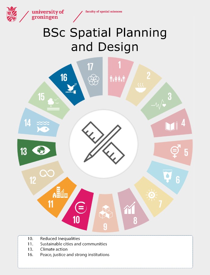
The courses in this programme have been scored against the United Nations Sustainable Development Goals. Find a general overview of how all of our programmes relate to the SDGs.
Year 1
Power of design (SD1) (5EC)
With help of real life examples, this course shows how designs are a planner s tool to connect a variety of interests and opinions into a seductive image of a possible future for a place. Every other week a project is visited.
Urbanism and Planning (SP1) (10EC)
In this course students learn more about the historical development of the Dutch Landscape. Students will also go into the latest thinking in key disciplinary areas, such as Urban History, City and Urban Planning, Planning History, Urban Sociology and Urban Studies. Students will learn to understand the evolution of urban governance and planning interventions.
Related SDG: 11 sustainable cities and communities, 16 peace, justice and strong institutions
Economic Geography (10EC)
The central theme in the course is the connection between (classic) economic-geography theory and actual economic-geographical developments. Can we (better) understand and describe the actual developments with the use of theory? This course incorporates a thorough introduction in the field of Economic Geography.
Related SDG: 10 reduced inequalities
Statistics 1 (5EC)
This course provides students with the skills to correctly select, apply and interpret a variety of descriptive and univariate statistical techniques.
Introduction to Academic Research (5EC)
The course teaches students what social-spatial scientific research means, what a research process looks like and how academic writing is done.
Spatial Design Atelier (SD3) (10EC)
In the period of February to April, the students will work 3 days per week in the design atelier: on the first day the students will work on design-thinking module and the remaining 2 days develop continuously their design project (research by design). Both modules make use of the 5 step design process (problem analysis, idea generation, idea evaluation and selection, and the realisation of ideas). The aim of the design studio is to create a plan/vision with these steps to address concrete spatial issues on different scales (real-world-planning/design problems) in a pre-defined project site with the analytical skills of complimentary 1st year courses (economic geography, statistics, GIS and demography).
Related SDG: 11 sustainable cities and communities
Geographic Information Systems (10EC)
Geographic Information Systems (GIS) are designed to collect, analyze and display spatial data to solve spatial problems. Central in this course is the ability to address geo-spatial questions with GIS in a research context.
Spatial Design Standards and Conditions (SD2) (5EC)
Spatial planning and design requires more than just visions and concepts. In order to translate those dreams to reality as future spatial planners, students will learn in eight weeks, the technical aspects of the spatial planning process (building regulations, design guidelines, planning law and policies, and project management processes) and how they are applied in the Dutch and international planning practice.
Related SDG: 11 sustainable cities and communities
Year 2
Mobility and Infrastructure Planning (10EC)
This course is divided into three blocks: (1) the explanation of mobility and network developments; (2) the measuring and analysis of mobility and infrastructure planning issues; and (3) the development of policies and instruments to resolve said issues. In addition to the lectures and student presentations, there will be a group assignment, three interim digital tests and excursions.
Related SDG: 11 sustainable cities and communities
Introduction to Qualitative Research (5EC)
The course is an introduction to qualitative research in geography and planning studies. It trains students in an active manner in the philosophies, skills, and techniques of different qualitative methods, among which interviewing and thematic (content) analysis. The course is built around the idea of experiential learning. It contains flipped classrooms for which students need to prepare by interactively engaging with short videos, audio and texts which will then be discussed in class; and learning labs which may take the form of e.g. workshops or walk-in feedback hours. The course consists of 3 blocks, about respectively (1) the research design cycle; (2) the data collection cycle; (3) the analytic cycle.
Urbanism Atelier (SD4) (5EC)
The Urbanism course is a design studio where students are working in design teams developing design proposals in the wider field of urbanism with a particular focus on the urban realm. Research by design and transdisciplinary research are guiding principles for the design studio. The topics and projects are real world (planning) problems – in close cooperation with the Groningen Planning Department (ROEZ Groningen) suitable topics are chosen. The students will work and develop their projects in close contact with different stakeholder, public actors, colleagues from planning/architecture consultancy and neighboring fields in academia.
Related SDG: 11 sustainable cities and communities
Water and Planning (10EC)
Developments such as sea level rise, shifting precipitation patterns and diminished natural resilience following flooding and water shortages have strengthened the connection between water management and spatial planning. Traditionally, water management was aimed at solely taking technical measures, such as building dikes, dams, and enlarging drainage capacities. The awareness of climate change and increasing flood risks, however, have led to the development of new, more spatial modes of flood protection. From an integrated perspective, and taking into account the whole water system and its specific characteristics, spatial planners now have to create more space for water and think about ways to ‘live with the water’ instead.
Related SDG: 16 peace, justice and strong institutions
Governance Dynamics (5EC)
This course unit builds on the basic general knowledge of spatial planning and geography gained in the first-year courses of the BSc in Spatial Planning and Design. It examines the fundamentals of planning and policy systems, with a particular emphasis on policy for the daily environment.
Related SDG: 11 sustainable cities and communities, 16 peace, justice and strong institutions
Physical Geography (5EC)
The lectures will provide a thematic introduction to physical geographic subjects. A number of themes will be dealt with, such as climate (change), geology, soil science, hydrology, coastal zone processes, ecology and environmental issues. These topics will be linked to current environmental problems and there will also be a focus on the relationship between the physical condition of the earth and human use of the earth.
Related SDG: 13 climate action
Statistics 2 (5EC)
This course provides students with the skills to correctly select, apply and interpret a variety of multivariate statistical techniques. Content-wise, this course builds on Statistics 1.
Applied Statistical Research Methods (5EC)
Landscapes (5EC)
In several lectures and day-long practicals, students will work with physical geographic information sources, like thematic maps, soil monoliths, spatial digital datasets, background literature and field data. During a field course near Eext (Drenthe) that will last several days, small groups of students will investigate the physical geographic condition and land use of a Dutch rural area and the relationship between cultural history and current use of the landscape.
Philosophy of Social Science (5EC)
This course consists of two themes aimed at helping students better understand the assumptions all researchers make in designing and carrying out a research study. The first theme focuses on the philosophy of the social sciences. The second theme focuses on the research cycle. In structuring this course, deliberate attention was given to have an interplay between these two themes, in order to help students to arrive at a deeper understanding of the assumptions underlying decisions made in the research act, and in the process, to also give students more practical skills in designing elements of their own research study.
Year 3
Bachelor's Project (15EC)
The Bachelor’s Project constitutes the final component of the bachelor Spatial Planning and Design. You will put into practice everything you have learned during the programme. This is an individual project. The coordinator provides a theme and the student can choose a subtheme.
Environment and Engineering (5EC)
The Environment and Engineering module deals with conditions from environmental science relevant to spatial planning. Understanding sources and atmosphere based propagation of physical-chemical environmental components like air pollution, noise, radiation and also safety are a prerequisite to spatial planning.
Related SDG: 11 sustainable cities and communities, 13 climate action
Planning Dynamics (5EC)
The course provides students with an overview about the practice of spatial planning and helps them demarcate a position (a role) for themselves as a future planning practitioner who plays a role in the field, and to understand different fields (specialisms) and their related dynamics in different cultures of planning. Therefore, it looks at social, administrative, political and spatial planning processes in a national and international context. This entails comparing the Dutch situation with planning and policy systems elsewhere in the world.
Related SDG: 16 peace, justice and strong institutions
Environment and Planning (5EC)
On a general level the course Planning & Environment deals with tensions and linkages between centralised and decentralized forms of policy making. It uses a perspective to differentiate between these forms of policy making based on the idea that the degree of complexity of the issues and circumstances faced.
Related SDG: 13 climate action, 16 peace, justice and strong institutions
Electives (30EC)
You can follow a minor, separate electives and/or electives abroad. You can also do an internship. For an overview of possible courses, please visit our course catalogue Ocasys.