The Groningen Institute for Archeology and the Niedersächsisches Landesamt für Denkmalpflege start participation project "De Verdwenen Eems"
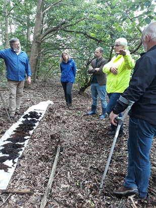
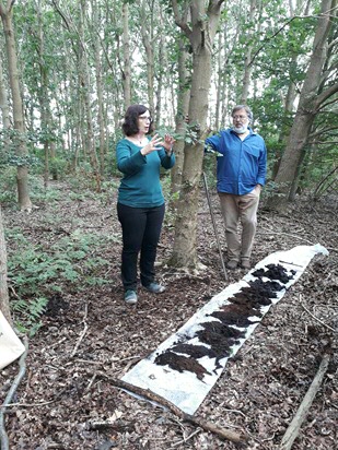
A long time ago, a mysterious river passed the German-Dutch border near Wessingtange in East Groningen. This river originated at Oberlangen, as a branch of the Eems. The (nameless) river was approximately 80 meters wide but became completely landed. The old loop is only observable to the trained eye. The initiators of the project want to find common roots in the area. This morning, the official start sign for the project "De Verdwenen Eems" with that aim was given. During the meeting, which took place in a small committee due to corona restrictions, a demonstration of a core drilling to explain the project on location in Emsland was given.
Structure of the participation project
With the help of core-drilling, pollen analysis, 14C dating and other methods, a reconstruction is made of the history of the Eemstak and its significance for the peasant population, who settled on its banks in prehistoric times. This riparian zone formed the last land connection between Westerwolde and the high grounds along the Ems, before Bourtangerveen took possession of the area. One of the research questions focuses on what the people did there and why they left shortly before the beginning of the era. Landing and advancing peat growth seem to be the main reasons, but new research will have to reveal whether this is correct.
Involvement of the environment
The current local residents and especially farmers are closely involved in the research. Through discussions, lectures, accessibility of the fieldwork and via social media, the goal and the methodology are illustrated. The purpose of the study is twofold. Prof. Henny Groenendijk, connected to the Groningen Institute of Archeology (Faculty of Arts of the University of Groningen), indicates that he would like to know how former residents lived in this area. “What influence did specific area characteristics (a river through a swamp) have on people's trade and walking and why did they disappear there. That adds a story to an area with little ancient history so far. On the other hand, we also want to understand more generally what the relationship is between residents of an area, what the properties are of an area and how the current residents themselves think and talk about them. The latter is also important for the researchers, so that they learn to recognize it.”
European Regional Development Fund
The project is co-financed under the INTERREG Deutschland-Nederland with resources from the European Regional Development Fund (ERDF) and by the provinces of Drenthe, Fryslân and Groningen, as well as the federal state of Niedersachsen. The project will run until the end of 2021.
More information about the project can be found on the website de-verdwenen-eems.nl/die-verschwundene-ems.de.
More news
-
28 April 2026
Groningen on the map as European capital of hip-hop
-
18 April 2026
Combating climate injustice through art
-