North Sea fisheries show a preference for unusual habitats
A broad analysis of three types of fishing – beam trawling for sole, beam trawling for plaice and otter fishing for Nordic lobster and flatfish – has shown that fisheries frequent very specific habitats in the North Sea. Researchers from the University of Groningen (UG) and Wageningen Marine Research (WMR) published on this topic in the academic journal PLOS One on 18 December. There are just a few habitats in the North Sea that are exploited intensively by fisheries. The majority of these so-called hotspots lie within ‘Natura 2000’ areas, as they are also very valuable for nature.
This study, conducted within the collaborative project DISCLOSE, provides the very first insight into the ecological characteristics of different habitats that are targeted by fisheries in the North Sea. The results emphasize that the fishing pressure on the seabed is not uniformly spread across the North Sea. Fishing hotspots are characterized by a combination of specific environmental characteristics that are possibly very important for nature. This could lead to a conflict of interests. The current regulations do not account for this information.
No big blue lake
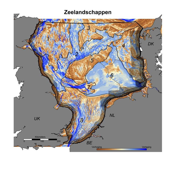
On most topographical maps, the North Sea is displayed as a big blue lake, but in reality, it accommodates a variety of sea landscapes. These include, among others, a landscape that was drowned following the last ice age and further shaped by tides, currents and waves. Underwater sand dunes, vast mud planes, flooded deltas such as the Klaverbank and high ‘underwater moraines’ such as the Doggersbank dominate these sea landscapes. By looking at these sorts of structures and the surrounding relief, nine sea landscapes in the southern and central North Sea (see figure: Zeeladschappen) were be typified in this study. All of these landscapes in turn have their own specific gradients of environmental variables, such as water depth, temperature, salinity and substrate.
Fishing at the landscape scale
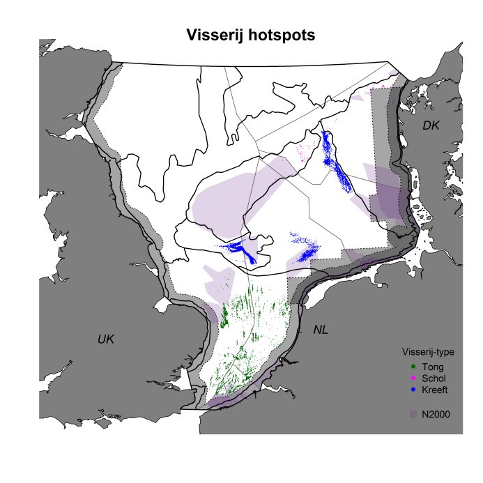
This research looks at how the Dutch North Sea fisheries use these landscapes. An analysis of the satellite position data of the three most important types of Dutch fisheries shows clear ‘fishing hotspots’ – spots that are intensively fished every year (see figure: Visserij hotspots). Some of these hotspots lie in the Dutch exclusive economic zone (EEZ), and one part lies in the EEZ of the United Kingdom, Belgium, Germany and Denmark. By connecting the locations of these hotspots to their environmental factors, the habitats in which the fisheries are most active as well as the ecological characteristics of these preferred spots were deduced. In addition, the study investigates how general the spots with these characteristics are.
Very exact
Head researcher Karin van der Reijden from the UG: ‘The hotspot analysis demonstrated that the three types of fishing studied at different locations in the North Sea are each conducted under unique circumstances. Sole fisheries are active in the southern North Sea, especially in the deeper troughs between the large sand banks. Nordic lobsters are actively fished in the muddiest areas, in the deeper parts of the Dutch part of the North Sea. The plaice fisheries fish more broadly, but still prefer the tops of sand waves, situated on the sides of the Doggersbank, for example.’
These specific preferences are connected to the occurrence of the target species of these fisheries: sole, plaice and lobster. The fisheries know precisely which parts of the sea landscapes they must visit in order to find the right species – and therefore, they indirectly know the environmental variables that these species prefer.
Goal-oriented protection of underwater landscapes
This study has demonstrated that sea landscapes are not all used in the same manner by fisheries and that most fishing hotspots are located in fairly rare habitats, with possibly a specific wealth of marine life. The expectation of rich marine life in exactly these areas was not studied but is supported by the fact that multiple fishing hotspots lie within the bounds of ‘Natura 2000’, a European network of protected habitats. This hotspot study creates an improved knowledge base for the weighing of interests, namely the protection of nature and fishing, as part of the sustainable management of the North Sea.
Publication: Van der Reijden K.J., Hintzen N.T., Govers L.L., Rijnsdorp A.D., Olff H. (2018); North Sea demersal fisheries prefer specific benthic habitats. Plos One, DOI: 10.1371/journal.pone.0208338 - http://journals.plos.org/plosone/article?id=10.1371/journal.pone.0208338
See also: https://www.noordzee.nl/bescherming-4-natuurgebieden-goede-stap-op-weg-naar-herstel-noordzeenatuur/
For more maps of the fishing hotspots visit:
https://arcg.is/0KrbWz
For more information , please contact UG spokesperson Jorien Bakker, tel. 06-11800452, or first author Karin van der Reijden, tel. 06-25247672, k.j.van.der.reijden @rug.nl
About DISCLOSE : In order to protect the North Sea effectively, we must understand it well. The four-year research project DISCLOSE, which runs until March 2020, charts the nature on the seabed by using various techniques. The project pays extra attention to the breadth, structure and functioning of vulnerable benthic communities. The project is a collaboration between Delft University of Technology, the Royal Netherlands Institute for Sea Research (NIOZ), the University of Groningen and Stichting De Noordzee and is made financially possible by the Gieskes-Strijbis fund. DISCLOSE stands for DIstribution, StruCture and functioning of LOw-resilience benthic communities and habitats of the Dutch North Sea; see https://discloseweb.webhosting.rug.nl/nl/
More news
-
-
-
01 April 2026
Why is our heart to the left and the liver to the right?