
Collectie kaarten en atlassen
De kaartenzaal is een onderdeel van de Afdeling Bijzondere Collecties en bestaat uit een cartografische handbibliotheek en uit oude en nieuwe atlassen en kaarten. De handbibliotheek kan op de zaal worden ingezien evenals het oude atlas- en kaartmateriaal dat in de kluis en in het magazijn ligt opgeborgen. Voor grote kaarten en atlassen is er ook een aparte grotere studietafel waarop deze geraadpleegd kunnen worden. Er is ook een lijst met de nieuwste aanwinsten op de kaartenzaal.
Digitaal beschikbaar
De verzameling losse kaarten — manuscriptkaarten en gedrukte kaarten — van de Universiteitsbibliotheek Groningen wordt bewaard in de kluis. Alle kaarten die vóór 1901 zijn getekend of uitgegeven, zijn gedigitaliseerd en online beschikbaar. Veel van deze kaarten komen uit de verzameling van Mello Backer en hebben Groningen (stad en provincie) en omringend gebied (Drenthe en Oost-Friesland) als onderwerp. Ook de rest van Nederland en Europa is goed vertegenwoordigd. In totaal betreft het hier ongeveer 800 kaarten, waarvan zo'n 200 uit de collectie ‘Groningana’ van Mello Backer. De indeling is geografisch, van een klein naar een groter gebied (provincie, land, werelddeel, wereld).
De collectie
De Universiteitsbibliotheek bezit een algemene cartografische collectie met nadruk op nationale, topografische, geografische en thematische atlassen. Door middel van vele facsimiles van oude atlassen en kaartboeken kan de gebruiker ook een beeld krijgen van de geschiedenis van de cartografie. Verder wordt geprobeerd een goede doorsnee te verkrijgen van de producten van de bloeiperiode van de Nederlandse cartografie van de 16e-18e eeuw. Speciaal verzamelgebied: Noord-Nederland (Groningen, Drenthe en Oost-Friesland).
Wist u dat...?
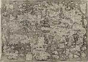
In de Cronycke van Hollandt Zeelandt en Vrieslant van Cornelius Aurelius uitgegeven in Leiden door Jan Seversz in 1517 — een in de kluis van de afdeling Bijzondere Collecties aanwezig boek — de oudste in Nederland gedrukte kaart meegebonden is? Deze kaart is in hout gesneden door Cornelis Henricsz Lettersnyder — rechts onder in het kleine vierkantje staat zijn vignet C.H. met de pot er onder — en werd drie jaar eerder in 1514 al gedrukt door Jan Seversz. Deze kaart is aan de Divisiekroniek uit 1517 toegevoegd. Links onder in het vierkant het drukkersmerk van Seversz met er op het wapen van Leiden met daar weer boven staat het jaartal 1514.
Herkomst en verwerving
De Universiteitsbibliotheek verkrijgt atlassen en kaarten door aankoop en schenking. Het ‘Groningana’-legaat van Mello Backer dat in 1899 in de UBG terecht komt, bevat naast boeken ook een verzameling atlassen en losse kaarten met betrekking tot stad en provincie Groningen, waaronder vele manuscriptkaarten. Andere schenkers van kaarten aan de UBG waren o.a. Acker Stratingh (vader) en Pelinck Stratingh (zoon) (1925) en de Bibliotheek van de provincie Groningen (1989).
Omvang
- handbibliotheek: 1300 titels
- atlassen van voor 1940: 200 titels
- atlassen van voor 1800: 30 titels
- losse kaarten: 1300
- gevouwen kaarten, meest stadsplattegronden: 550 (aanvraagnr.: uklu D)
- wandkaarten om stok gerold: 30 (aanvraagnr.: uklu Rol)
- topografische kaartseries:1 : 25.000 en 1 : 50.000 vanaf 1970-heden
- thematische kaartseries (deels Noord-Nederland): bodemkaart / geologische kaart / geomorfologische kaart /waterstaatskaart
Toegang tot de collectie
Alle boeken uit de handboekerij, de kaarten en de atlassen zijn in de catalogus te vinden. Er is ook een fiche-catalogus op de zaal op regio, kaartmaker en kaarttitel (na 1990 niet meer bijgehouden).
Op de zaal kan men inzien:
- overzicht van cartografische artikelen uit tijdschriften en jaarboeken over Groningen, Drenthe en Oost-Friesland
- overzicht van de aanwezige topografische kaarten van 1:25.000 en 1:50.000
- overzicht van de kaartbijlagen van The National Geographic
- aanwinstenlijsten van nieuwe boeken in de handbibliotheek
- aanwinstenlijsten van nieuwe kaarten en atlassen.
Collecties verwant aan de Rijksuniversiteit Groningen
Binnen Groningen
Groninger Archieven : historisch informatiecentrum voor stad en provincie Groningen. Zeer uitgebreide kaartcollectie met betrekking tot stad en provincie.
Literatuur over onze cartografische collectie
- 'De kaartencollectie van de bibliotheek der Rijksuniversiteit te Groningen' / Wil Groothuis, in: Caert-thresoor (1990), no. 3, p. 37-41 .
- [8 beschrijvingen van oude kaarten uit de collectie van de UBG] / Wil Groothuis en Cathrienus Schaafsma, in: De wereld aan boeken. – Groningen : UBG, 1987. – p. 109-118
- Lijst van kaarten van gedeelten der provincie Groningen en der geheele provincie Groningen / verzameld door M. Backer. - Groningen : Gebr. Hoitsema, [1874]. - 42 p. ; 23 cm. - (Bijdragen tot de kennis der provincie Groningen ; 18e st.)
- Beredeneerde lijst van plattegronden der stad Groningen / verzameld door … M. Backer. – [S.l. : s.n., 19e eeuw]. – 10 bl. (uklu HANDS BACKER 61)
Literatuur met betrekking tot atlassen en kaarten
Noord-Nederland
- Hoogtepunten van de Friese cartografie : kaarten van provincie, goën, grietenijen, plattegronden van steden en dorpen, verveningen, slatten, dijken / P.J. de Rijke. - Leeuwarden : Friese Pers Boekerij, cop. 2001. - 114 p. : krt. ; 40 cm
- De Hottinger-atlas van Noord- en Oost-Nederland 1773-1794 / H.J. Versfelt. - Groningen : Heveskes, 2003. - 71 p., [188] p. pl. : krt. ; 34 cm.
- De Franse kaarten van Drenthe en de noordelijke kust, 1811-1813 / H.J. Versfelt, M. Schroor. - Groningen : Heveskes, 2001. - 85 p., 39 p. krt. : ill., krt.
- Kaarten van Drenthe : 1500-1900 / H.J. Versfelt. - Groningen : Heveskes, 2004.
- De atlas van Huguenin : militair-topografische kaarten van Noord-Nederland : 1819-1829 / H.J. Versfelt en M. Schroor. - Groningen [etc.] : Heveskes, 2005. - 135 p., 85 p. krt. : ill. ; 34 cm
- Biografie van de Bosatlas : 1877-heden / Ferjan Ormeling ; met medew. van Rob van der Vaart. - Groningen : Wolters-Noordhoff Atlasproducties, 2005. - 136 p. : ill., krt. ; 36 cm
- Grote Atlas van Nederland 1930-1950 = Comprehensive Atlas of the Netherlands 1930-1950 / [tekst:] B.C. de Pater, B. Schoenmaker ; [samenstelling en onderzoek:] R.C.M. Braam ... [et al.] ; begeleidingscommissie Koninklijk Nederlands Aardrijkskundig Genootschap//Royal Dutch Geographical Society Advisory Committee: P. van den Brink ... [et al.] ; [eindred.: J.R. van Diessen]. - Zierikzee : Asia Maior/Atlas Maior ; Utrecht : KNAG ; 's-Gravenhage : Nederlands Instituut voor Militaire Historie, 2005. - 584 p. : ill., krt. ; 49 cm
- Frisia dominium : kaarten van de provincie Friesland tot 1850 : geschiedenis en cartobibliografie / P.J. de Rijke. - 't Goy-Houten : Hes & De Graaf Publishers, cop.2006. - 452 p. : ill., krt. ; 33 cm. -(Utrechtse historisch-cartografische studies, ISSN 1568-2072 ; 4)
- De historische atlas van Assen / Jan Battjes, Egbert Brink. - Assen : Koninklijke Van Gorcum, cop. 2009. - 96 p. : ill. ; 31x30 cm
Provincie Groningen
- De atlas van Kooper : oude kaarten van de provincie Groningen / Meindert Schroor ; met medew. van: Auke Hummel, Hilda Raap ; [red.: Hilda Raap ; register Klazien Schroor-Dijkstra]. - Bedum : Profiel, 2003. - 160 p. : ill., krt. ; 35 cm
-De atlas der stadslanden van Groningen (1724-1729) / Meindert Schroor ; [fotogr. kaarten: John Stoel]. - Groningen : REGIO-PRojekt Uitgevers ; Groningen : Gemeentearchief Groningen, 1997. - 53 p., [140] p. krt. : ill., krt., plgr. ; 34 cm
- De atlas der provincielanden van Groningen (1722-1736) / Meindert Schroor ; [bureaured. M.I.W. Jager ; fotogr. krt. P. Schuurmans]. - Groningen : REGIO-PRojekt Uitgevers, 1996. - 50 p., 126 p. pl. : ill., krt. ; 34 cm
- Dollardzijlvest, gepeild en aangekaart : een kartografische kijk op de geschiedenis van land en water in het Oosten van Groningen en Drenthe / red.: J.N.H. Elerie ... [et al.] ; in samenw. met J.D.R. van Dijk en W.R. Foorthuis. - Groningen : Van Dijk & Foorthuis Regio PRojekt, 1992. - 108 p. : ill., krt. ; 24×28 cm
- De kaarten van Groningerland : de ontwikkeling van het kaartbeeld van de tegenwoordige provincie Groningen : met een lijst van gedrukte kaarten vervaardigd tussen 1545 en 1864 / door J.J. Vredenberg-Alink. - Uithuizen : Bakker, 1974. - 151 p. : ill., krt. ; 31 cm
- Geschiedenis van Stad en Ommelanden in kaart : gids voor de lustrumtentoonstelling, 21 juni t/m 29 juni 1969 / gastred.: H. Vrielink. - [Groningen : Groniek], 1969. - 96 bl. ; 30 cm. - (Groniek. onafhankelijk Gronings historisch studentenblad ; [no. 2] spec. uitg)
- Groninga dominium : geschiedenis van de cartografie van de provincie Groningen en omliggende gebieden van 1545-1900 / Piet H. Wijk ; [red.: Ekkers & Paauw ; fotogr. Jan Buwalda ... et al.]. - Groningen : Elchers ; Assen : Van Gorcum, 2006. - 372 p. : ill. ; 33 cm
Stad Groningen
- De plattegrond van de stad Groningen door Jacob van Deventer uit omstreeks 1565 : vorming en vernietiging van een kaartbeeld / door G. Overdiep. - Alphen aan den Rijn : Canaletto, 1984. - 146 p. : plgr., foto's, ill. ; 20x27 cm + losse kaart en plattegrond
- Egbert Haubois : bijdrage tot de kennis van leven en bedrijf van een zeventiende-eeuwse ingenieur en kaartmaker in Groningerland / door W.K. van der Veen. - Alphen aan den Rijn : Canaletto, 1983. - 98 p. : ill. ; 19x27 cm + Kaart
- Historische atlas van de stad Groningen : van esdorp tot moderne kennisstad / Meindert Schroor ; [eindred. Lucy Klaassen ... et al.]. - Amsterdam : SUN, cop. 2009. - 80 p. : ill., krt. ; 34 cm. -(SUN-historische atlassen). - Uitg. in samenw. met het Regionaal Historisch Centrum Groninger Archieven
- De kaart van Egbert Haubois : spiegel van wens en werkelijkheid / [red. Lies Boiten ... et al. ; bijdragen van W.K. van der Veen ... et al.]. - Alphen aan den Rijn : Canaletto ; Groningen : Groninger Museum, 1983. - 144 p. : foto's, tek., krt. ; 19x27 cm + kaart