Major GIA projects
The Impact of Roman Imperialism in the West
The project “The impact of Roman imperialism in the West: settlement dynamics and rural organization in Iron Age and Roman Portugal” is a landscape archaeological and ancient historical study of the westernmost area that was conquered by ancient Rome and incorporated into the Roman empire (c. 3rd-1st centuries BCE). Using a combination of new archaeological field work and digital geospatial technologies, as well as a study of previous archaeological and historiographical work, the project aims to generate new understandings of the Roman archaeology of the western Mediterranean.
Learn more about The Impact of Roman Imperialism in the West

MARE – Mortuary Archaeology of the Roman East (Dutch Research Council – VICI)
During the first centuries CE, new forms of funerary display emerged in the cemeteries of the Roman Near East. Memories of the deceased were prolonged after death through portraits and epitaphs, monumental stone coffins, and roadside tombs. This project investigates how these forms of displaying the dead were embedded in mortuary rituals. Bringing legacy dataset and digital archives together, we interrogate how local communities reformulated their relationships with the dead by personalizing the funerary spaces.
Over a period of five years (2021-2026), team members will concentrate on three area: Roman Lebanon, Syria (Palmyra), and Turkey (Pisidia). Fostering close collaboration between archaeologists, historians, art historians, and computer engineers, a digital infrastructure is developed to enhance legacy and orphaned datasets from coastal Lebanon, Palmyra, and Pisidia, as well as to unlock inaccessible collections for wider audiences.
Finding Suitable Grounds
Finding Suitable Grounds is a 5-year project funded by the Dutch Research Council (NWO), based at the University of Groningen and Utrecht University, in collaboration with Universitat Pompeu Fabra, RAAP, BIAX, Cultural Heritage Agency of the Netherlands and the Free University of Brussels. The project studies the setting and speed of adoption of crop cultivation in the lowlands of the Netherlands, since the onset of the Neolithic (6000-4000 BC). Read more on Finding Suitable Grounds.
Salt and Power. Early States, Rome and Resource Control
Salt is indispensable to society, past and present. Human and animal health depend on this resource, as did the preservation of food in the past. Salt was the only means available to preserve and trade foodstuffs essential for the first large towns with thousands of citizens. For central Italy’s early city-states, control over salt resources was crucial. The project aim is to establish how salt was produced before their installation and how salt production kept pace with the rising population of the early states, in particular Rome. We will investigate these questions with an up-to-date methodology to contribute with a historically important case study to the global archaeological and anthropological debate on salt-making and resource control in the context of prehistoric and early state societies. The 4-year project is based at the University of Groningen and funded by the Dutch Research Council (NWO). Read more on Salt and Power.
Resurfacing Doggerland
Resurfacing Doggerland is a 5-year project based at the University of Groningen and funded by the Dutch Research Council (NWO), with co-funding by the Cultural Heritage Agency. The central goal of the project is to study the effects of sea-level rise on hunter-gatherers who, between 20,000 and 7,000 years ago, were dwelling in the southern North Sea region, an area often referred to as ‘Doggerland’. Read more on Resurfacing Doggerland.
EDAN | The Emergence of Domesticated Animals in the Netherlands
The Emergence of Domesticated Animals in the Netherlands (EDAN) is a 3-year project funded by the Dutch Research Council (NWO) and based at the University of Groningen. The central aim of this project is to shed new light on the biocultural, economic, and chronological aspects of early animal husbandry in the Netherlands (c. 5000 - 3500 cal BC). Read more on EDAN.
The Roman Hinterland Database Project
The Roman Hinterland Database Project is a collaborative effort to combine 70 years of intensive archaeological field survey data in the hinterland of Rome into the largest contiguous dataset for the Mediterranean world.
The project has brought together, since its start in 2015, the British School at Rome’s Tiber Valley Project (the restudy of J.B. Ward-Perkins’ ground breaking South Etruria Survey), La Sapienza University’s study of the Suburbium immediately adjacent to the city of Rome, and Groningen University’s long-standing series of survey projects in the Pontine region to the south of Rome. We have successfully combined in a single database hundreds of thousands of artefacts, and thousands of sites, for the millennium of 500 BCE to 500 CE, all georeferenced and systematically classified. This database offers an unparalleled opportunity to study the impact of Rome’s ascent and decline on its hinterland. No other major world metropolis has such a wealth of archaeological data across such a long period.
The project’s twofold ambition now is to:
-
use this data to investigate new interpretations of the impact of Rome, and of cities more generally, on their surrounding rural areas, from infrastructure and trade to ecology and demography.
-
use the techniques of data aggregation piloted in this project to extend the survey dataset to other parts of peninsular Italy and the Mediterranean, fostering the kinds of large-scale and high-resolution spatial comparisons that have so far been impossible.
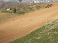
FAIR Surveys Project
Dozens of field walking surveys take place every year across the Mediterranean, using a wide range of approaches. Attempts are being made to provide single online access to information about these projects (e.g., at www.fastionline.org), but generally this gives no access to the data sets themselves. There is some degree of consensus about good practice in designing and conducting these surveys, and in processing and analyzing the finds; this is currently being documented and prepared for publication by the IMS network of Mediterranean survey practitioners (Attema, Bintliff, van Leusen forthcoming). Researchers have long expressed the desire to conduct comparative and complementary analyses across surveys but have so far been frustrated by the (often undocumented) differences between datasets.
In a separate development, the archiving of survey projects at repositories such as DANS-EdNA in the Netherlands, and ADS in the United Kingdom, has presented PI's with the problem that the archive's rules allow the deposition of datasets that are not sufficiently documented, placing in serious doubt the idea that such archived data should be re-usable in future research. In the (digital) archiving world, the rule is that archives should be FAIR: Findable (i.e. structured metadata about them should be available online), Accessible (it must be possible to obtain the archives themselves), Interoperable (they must be in a format that can be read and interpreted), and Re-usable (the meaning, scope, and limitations of the data in the archives must be made clear).
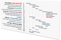
In 2015, Dr Martijn van Leusen and Dr Tymon de Haas (now at Cologne University) began to investigate a solution called CRM (Conceptual Reference Modelling) to both of these problems. CRM can be used to explicitly and systematically document and describe all relevant aspects of a survey dataset, so that if it is placed in an archive like DANS, it will comply with the FAIR principles; it can also provide a unified description system that, if applied by other survey PI's, will allow the comparison and merging of survey datasets. The FAIR Surveys Project began in 2016 with the help of a DANS/KNAW 'small data project' grant, which was used to draft and test a CRM for survey datasets; this is now being further developed with the help of the CIDOC CRM-special interest group and of colleagues in the survey community. In the meantime, Van Leusen and De Haas have presented the project at the September, 2017 EAA conference in Maastricht and are working to obtain EAA support for it. The project aims, in conjunction with similar CRM efforts in the field of archaeological excavation, to produce a formally recognised archaeological extension to the CIDOC CRM, and eventually to offer a software toolset that will allow survey PI's to convert their databases to fully FAIR and CRM-compliant datasets. These will be ready for the next big step: publication as Linked Open Access Data.
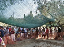
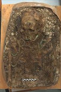
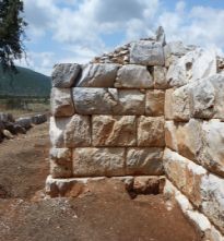
Ayios Vasilios North Cemetery Excavation
The excavation of the North Cemetery part of the Ayios Vasilios Project, directed by Mrs A. Vasilogamvrou, Director Emerita of the Laconia Ephorate, carried out under the auspices of the Archaeological Society at Athens and supervised by the Laconia Directorate of Antiquities. The excavation of the North Cemetery is directed by Prof S. Voutsaki. The cemetery is situated at a small distance of the palatial buildings at Ayios Vasilios, but belongs to an earlier phase, probably MH III to LH II. The cemetery consists of ca. 20 tombs which range from small pits to a large built tomb, though the majority are large, well-built cists. The mortuary practices are characteristic of the early Mycenaean period: the graves are re-used, primary burials are found in extended position, secondary treatment is attested, but they are unfurnished or poor. The study of the cemetery, which is excavated with state-of-the-art excavation and recording techniques will shed light to the early, formative stages of the important regional centre in Ayios Vasilios. The Project is financed by the GIA, by Ammodo Foundation, the Netherlands, the Mediterranean Archaeology Trust, UK, the Institute of Aegean Prehistory, USA and the Kaplan Foundation, USA.
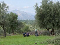
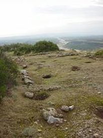
Ayios Vasilios Survey Project
The Ayios Vasilios Survey Project is part of the Ayios Vasilios Project, directed by Mrs A. Vasilogamvrou, Director Emerita of the Laconia Ephorate, carried out under the auspices of the Archaeological Society at Athens and supervised by the Laconia Directorate of Antiquities. The survey is co-directed by Prof S. Voutsaki and Mrs A. Vasilogamvrou, and Dr C. Wiersma acts as field director. The main aim of the survey project is to reconstruct the extent and boundaries of the settlement through time, and shed light onto the process of growth and urbanization of this important regional centre. Use is made of two non-invasive research methods (geophysical prospection and field survey), while trial trenches are also planned for the future.
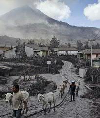
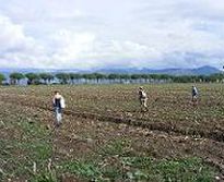
The Avellino Event: Cultural and demographic impacts of the giant Bronze Age eruption of Mount Vesuvius
Around 1995 BC, during the Early Bronze Age, a giant eruption of Mount Vesuvius buried a flourishing landscape of villages and fields in the plains to the north and east of the volcano under more than a meter of ash. Inhabitants of Campanian sites such as Nola (‘the Bronze Age Pompeii’) barely escaped with their lives. Italian archaeological research since the 1980s has already shown that the population of the Campanian plain did not fully recover for several centuries after this so-called ‘Avellino Event’, but no one has yet wondered where the substantial Early Bronze Age population of Campania could have sought refuge, or what impacts it would have had there.
GIA researchers dr. Martijn van Leusen and Prof. Peter Attema received € 750,000 to carry out an interdisciplinary study into the cultural and demographic impacts of the disastrous event. Their hypothesis is that given the topography of central-southern Italy, the most likely refuge area will have been to the north, in the coastal zone of what is now South Lazio. Here, two wetland coastal plains – the Fondi basin and the Agro Pontino - could have provided the space and resources to absorb the fleeing population. This research program starts on June 1, 2015 and will run for four years. The research team will be hosted at the Groningen Institute of Archaeology and the
Archaeobotany department of the Faculty of Archaeology, Leiden University.
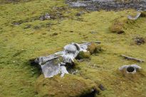
Anthropogenic impact on Svalbard ecosystems
This project was initiated by Maarten Loonen and Louwrens Hacquebord. It investigates local, regional and global anthropogenic impacts on terrestrial, fresh water and marine arctic ecosystems and consider the management of these resources over time. The project consists of 5 sub-projects granted by NWO (1,2 million grant), 2 conducted by the Arctic Centre, 1 by the department of Marine Biology (RUG), 1 by the department of animal behaviour (RUG) and 1 by NIOZ. There is a 6th affiliated project funded and carried out by Wageningen University and Research Centre.
Crustumerium: The People and the State (800-450 BC)
GIA’s research project “The People and the State, material culture, social structure and political centralization in central Italy (800-450 BC)” studies the effects of early state formation on the social fabric of village communities in central Italy during the period 800-450 BC on the basis of fieldwork in the settlement and burial grounds of the Latin settlement of Crustumerium near Rome. The project is directed by Peter Attema and Albert Nijboer and is jointly funded by the Netherlands Organisation for Scientific Research (520.000 €) and the Groningen Institute of Archaeology for the period 2010 – 2015. The project builds on earlier research at the Latin site of Crustumerium that was started by the GIA in 2006 in close collaboration with the Soprintendenza Speciale per I Beni Archeologici di Roma (SSBAR) and other international partners. The results of the NWO project are being published as PhD theses, conference volumes and a final synthesis due end of 2015.
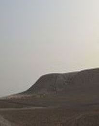
Erbil Plain Archaeological Survey project
The GIA has participated in the Erbil Plain Archaeological Survey (EPAS) since 2012 in Northern Iraq (Kurdistan), directed by Prof. Jason Ur (Harvard University) in collaboration with the Directorate of Antiquities for the Kurdistan Regional Government, and the State Board of Antiquities and Heritage. The project combines a study of historical satellite and aerial photographs with on the ground survey and investigates the long-term impact of ancient empires on the rural landscape of North Iraq. The main aim is to map and protect the rich archaeological landscape of a previously underexplored region of North Mesopotamia. The projects hosts various international scholars specialized in the prehistoric, Bronze and Iron Age, Sassanian, and Early Islamic periods. GIA’s involvement, under the direction of Lidewijde de Jong concentrates on the Hellenistic and Parthian era. Located in the Hellenistic heartland and in the zone of conflict between Romans and Parthians, investigation of the hinterland of Erbil provides new insights about the lives of local villagers between the 3rd century BC and the 3rd century AD. The first preliminary report was published in 2013 . The project is tied to de Jong’s larger project focusing on the archaeology, history, and environment of North Mesopotamia in the Classical, Byzantine, and Early Islamic era.
Fora, stationes, and sanctuaries: the role of minor centers in the economy of Roman Central Italy
This five year research project (2011-2016), co-financed by a €750.000 grant from the Netherlands Organization for Scientific Research (NWO) and the Groningen Institute of Archaeology (GIA, University of Groningen), was initiated by Peter Attema, Tymon de Haas and Gijs Tol. It aims to investigate the role of minor central places in the economy of Roman Central Italy, a class of sites which is so far little investigated, through an integrated set of non-invasive research methods, including field survey, geophysical prospections and typological and petrographic studies. The outcomes of the project will be presented in a synthetic monograph, a series of articles, and an online petrographic database.
Archaeological Research of the GIA in the Sibaritide (Northern Calabria, Italy).
The ARGS combines excavations, landscape surveys and specialist studies on material culture and the human environment at the protohistoric site of Timpone della Motta near Francavilla Marittima in Italy. The indigenous Oenotrian site of Timpone della Motta is located in the foothills of the coastal plain of the Sibaritide near the Greek colony of Sybaris in northern Calabria.The project was started in 2009 as an umbrella project following on earlier work carried out by the GIA from 1991 onwards, which in turn built on the Italian/Dutch archaeological investigations of the 1960’s. Now that GIA excavations at the site have been suspended, its main aim is to further the publication of PhD theses carried out at the GIA on various topics dealing with the site’s archaeology and the realization of monographs on the recent excavations in the sanctuary and settlement. ARGS is coordinated by Peter Attema from the GIA.
New Halos: a Hellenistic city and its Hinterland (Thessaly, Greece)
The archaeological investigation of New Halos and its territory was initiated by Reinder Reinders in 1976. The project is conducted as a collaboration between the Netherlands Institute at Athens and archaeologists from the University of Groningen, University of Amsterdam and the 13th Ephorate at Vólos (Greece). The focus of the project is on the city of New Halos itself: the environmental setting, its fortifications, the layout of the lower town with residential areas and the layout of the upper town where public buildings were situated. In a wider context, the project aims at investigating the territory that once belonged to the city of New Halos. Archaeological surveys are conducted to study the occupation history of the territory, covering all periods from Neolithic to recent times.
Shifting Identities Project
This international, multidisciplinary project is directed by Sofia Voutsaki and has received a Grant for Innovative Research by the Dutch National Research Foundation (NWO, € 618,000) as well as several research grants by different grant-giving bodies.
The aim of the project is to interpret the important social, political and cultural changes that took place in the southern Greek mainland during the Middle Bronze Age and the transition to the Late Bronze Age, or Mycenaean period (approx. 2000 - 1600 BC). The task is undertaken by means of an integrated analysis of settlement, funerary, skeletal and iconographic data from the Argolid, Northeastern Peloponnese. The central question of the project, the redefinition of personal, ethnic and cultural identities within wider processes of socio-political change, has a wider relevance beyond the Aegean and occupies a central position in current theoretical debates in archaeology.
The results of the project appear in a series of articles, three monographs and an edited volume.
The Digital Plant Atlas
The Digital Plant Atlas is an international project that makes a unique contribution to the identification of seeds, fruits, roots, tubers, bulbs, stem fragments, leaves, flowers, buds and resins. The plant parts are illustrated with high-quality colour photographs and accompanied by a scale and their scientific name. The local names in various languages are included in an index. In 2013, the Manual for the identification of plant seeds and fruits was published.
The Digital Plant Atlas is a joint project of the Groningen Institute of Archaeology (GIA), the Community and Conservation Ecology Group (COCON), both of the University of Groningen (the Netherlands), and the Deutsches Archäologisches Institut (DAI, Berlin, Germany). The books are published by Barkhuis in the Groningen Archaeological Studies series. The databases have been designed and are being maintained by the Digital Library section of the University of Groningen Library.
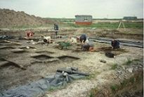
Unlocking Noord-Holland's Late Neolithic Treasure Chest
The project was initiated by Hans Peeters (then Dutch Cultural Heritage Agency, now University of Groningen) and received a € 500,000.- grant by the Dutch National Research Foundation NWO. The project combines the research expertise from researchers from the Cultural Heritage Agency, two universities and various firms. The project provides an opportunity to study a micro-region within the Single Grave Culture distribution, so far largely known from its burial context. Its place in relation to the communities in the central and eastern parts of the Netherlands can be assessed and possible long-distance contacts with related Corded Ware groups elsewhere can be studied, addressing the debate on the apparent uniformity of the Corded Ware Complex. These aims will be met by publishing three monographs on selected key sites: Keinsmerbrug, Mienakker and Zeewijk.
| Last modified: | 08 December 2022 09.42 a.m. |